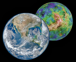
Planet Venus next to planet Earth, as in the flood.

Source: http://solarsystem.nasa.gov//planets/index.cfm)
The origin of the flood waters
If God separated the waters, He can also bring them together again. In the flood, God transferred the waters of Eden to Earth. Eden was transformed entirely into a lake that burns with sulfur because God destroyed it. Eden is the current planet Venus.
In Genesis 7:11 he reports that all the fountains of the great abyss were broken and the windows of heaven were opened. If the windows of heaven were opened then the waters came from space. It is understood that the Earth and Eden remained side by side for forty days, transferring the waters. The force of attraction of the planet has blown the Earth's mantle, breaking the sources of the great abyss.
There was an influx of water from space that enveloped the Earth and was received in the ground in the form of rain for forty consecutive days.
The increase in the volume of water
The relief of the Earth, before the flood, was aged by the action of erosion and allowed human migration between continents. In the flood, the waters rose 15 cubits (7 meters) above the high mountains (Genesis 7:20), but the high mountains were not the same height today. If you consider Everest as a reference among the high mountains. Today Everest is 8,848 meters high, due to the existence of marine sediments found at 7,800 meters high, it is assumed that it had 1,048 meters high before the flood (8,848 - 7,800). If the waters in 40 days of rain covered (fifteen cubits) above the high hills, then the waters rose 1055 meters above sea level, that is, 1048 meters plus 7 meters. Everest rose after the flood and still continues to rise an average of 10 cm per year.
There was not an ordinary rain, but an entry of water from the space that involved the Earth's orbit, received in the soil in the form of rain in the order of 1100 mm / m2, poured over forty consecutive days. A precipitation of 1100 mm / m2 of water fills a column of 1,055 meters in 40 days (40 x 24 x 1100 mm = 1055 meters), and corresponds to an increase equivalent to 62.5% of the waters existing before the flood. In order to double the volume of water on Earth, a water column 1680 meters high would be necessary.
Calculation:
Increase in the volume of water in the entire planet is equivalent: surface of the earth x water column of 1,055 meters = 5.10E14 m² x 1055 m = 5.39E17 m³
Percentage increase (%) of water volume is equivalent to: increase in water volume / total water volume before the flood = 5.39E17 m³ / (1.40E18 m³ - 5.39E17 m³) = 62.5%
Current share of continents and oceans:
Land area = 5.10E14 m²
Water volume = 1,40E27 m³ (1,386 million cubic kilometers)
Average depth of the seas = 3800 meters
Average height of the continents = 838 meters.
Table with the relative participation of the seas, 70.8% of the Earth's surface:

Source: http://www.ngdc.noaa.gov/
The uplift of the continents
The gravitational attraction between the two planets broke the crust (Genesis 7:11) and formed the tectonic plates, mainly under the oceans where the thickness of the crust is smaller (from 5 to 10 km), and to a lesser extent under the continents where the thickness is greater (from 25 to 50 km).
On the map below, the rupture and leakage of the magma is observed in red and the displacement in blue, exposing older layers of the crust.

Source: http://www.ngdc.noaa.gov/.
The earth's crust, once fragmented, gave way in the face of water pressure. The sinking of the crust under the oceans displaced the magma in a movement of accommodation causing the uplift of the adjacent continents in a slow and continuous way. In the Pacific, it is understood that this process was responsible for the formation of the Andes, the Rocky Mountains and the Himalayas. The Himalayas collaborated on the Indian and Pacific sides. In the South Atlantic, this process caused an inclination to the West of the Paraná basin (Brazil) and changed the course of the Tietê, Rio Grande and Rio Paranapanema rivers towards the West. There are large amounts of marine sediments, where the seabed used to be. Vila Velha in Paraná, which was at the bottom of the sea, is now 1,012 meters high.
On the map below, you can see the accumulation of waters and the continents very well delineated.

Source: http://www.ngdc.noaa.gov/.
There were two contributions to increasing the continents' participation in the flood. The first contribution was due to the rupture of the crust (tectonic plates) allowing the accumulation of water and the uplift of the reliefs by the isostatic effect. The second contribution was made by the launching of plates from the Venus (Eden) soil. The soil allowed to bring the vegetal diversity of Eden, and more, it created in the planet the inversion of the geological layer and of the fossil record, not of the Earth, but of Eden in the Earth.
Sea level
Researchers from USP (Kenitiro Suguio) using radiocarbon dating (approximately 700 dating) concluded that sea level (Brazilian coast) was 5, thousand meters above current level 5, thousand years ago. It must be considered that there was no decrease in sea level, but accommodation due to the flood. According to the same study, the sea level is now 120 meters above the level that existed 17, thousand years ago. Source: www.revistas.usp.br/guspsd/article/download/45427/49039
Supposing that there was a 62% increase in the volume of water from the flood, this increase is equivalent to a hypothetical column of 1,055 meters of water, and increases the diameter of the planet by 2,110 meters. Isostatic equilibrium makes the continents and the waters of the seas settle on the surface in proportion to the density of the elements. There should be a proportion of three parts of water to one of continent, considering the average density of the continents of 3.0 g / cm³. If you consider that the reliefs are on average 838 meters above sea level, then the proportion of terrestrial relief should be below 25%, something close to 20%, and not 29.2% (or 34.6% with platforms continent) as it currently stands. If the continents and seas are in balance, then the average density of the continents (disregarding continental elevations) should be 2.42 g / cm³ (0.708 / 0.292), the density would be even lower with continental elevations, which is not right. We conclude that the continents are far above what physics allows for global balance.
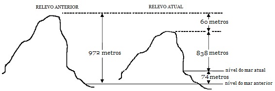
Supposing that the continents just after the flood had an average height of 972 meters and after 26 thousand years, due to accommodation and erosion of the continental mass, the average height of the continents dropped to 838 meters. In absolute terms, the continents sank 60 meters and the sea rose 74 meters (including the melting of glaciers, assuming a volume equivalent to the Antarctic continent, less the resulting isostasis) and caused the sea level to rise 134 meters in relative terms.
The post-flood sea level, according to the hypothesis presented.
These issues are clarified through the book Time of God, in Portuguese language.
See full subject:
Tempo de Deus.
https://odemori.blogspot.com/
Postagem em destaque
Tempo de Deus
TEXTO ATUALIZADO EM 12/02/2025 “E fui ter com o anjo e lhe pedi que me desse o livrinho. Disse-me ele: Toma-o, e come-o; ele fará amargo o...